|
|
|
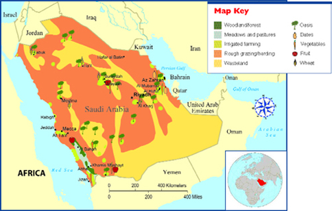
This map shows some of the physical characteristics of this country. When you look at this map you do not see a lot of the little icons all over the place. Saudi Arabia does not have a lot like other countries do because it is mostly desert.
What Are the Different Types of Maps and Graphs? - What Are Physical Maps?, What Are Political Maps?, What Are Special Purpose Maps? (2008). Retrieved February 9, 2015, from http://www.jrank.org/history/pages/8346/What-Are-Different-Types-Maps-Graphs.html |
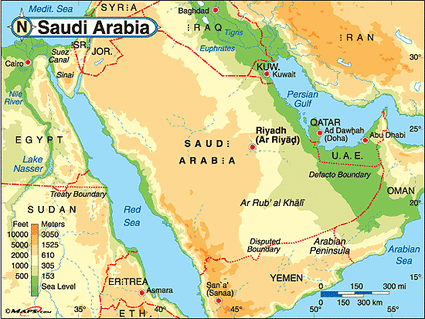
This map shows the elevation of Saudi Arabia and some of the surrounding countries. In Saudi Arabia you can see from the map that the elevation is ranging from sea level to 1000-1525 meters.
Saudi Arabia Physical Map. (n.d.). Retrieved February 9, 2015, from http://www.maps.com/ref_map.aspx?pid=12334 |

In this map you can see the different levels of precipitation in Saudi Arabia between 1950-2000. It goes all the way from 0 to 340. The areas of the map that have circles around them, the data was collected during the winter months (November - May).
Goal 1: Improve Understanding of the Atmosphere, Earth System, and Sun. (2008). Retrieved February 9, 2015, from http://www.nar.ucar.edu/2008/RAL/goal_1/priority_2.php
Goal 1: Improve Understanding of the Atmosphere, Earth System, and Sun. (2008). Retrieved February 9, 2015, from http://www.nar.ucar.edu/2008/RAL/goal_1/priority_2.php
